I have always had the idea, that past years the level of the North Sea has risen very rapidly. This is what the main stream media tries to make us aware of. Some meters rise coming years would be possible they say.
However, lately I bumped into this article:
https://klimaatgek.nl/wordpress/2021/01/17/de-zeespiegel-in-nederland-1901-t-m-2019/#more-7043
I found that the last 100 years the North Sea level rise is
lineair and does not show a grow acceleration. The absolute North Sea level
rise is appr. 15 centimeters in a century
(100 years).
This graph shows the average height of 6 sea costal
stations in The Netherlands.
In spite of this (only) 15 cm rise per century, I am not underestimating the forces of water and wind. I have a special interest in the sea level rise because I live on Goeree-Overflakkee. This island was struck by the ‘Watersnoodramp’ (North Sea flood) that took place in the night of 31 January/ 1 February 1953.
A combination of a high spring tide and a severe windstorm
over the North Sea caused a storm tide. Dykes broke and the sea flooded up to
about 6 meters above the mean sea level.
Today, this happened exactly 68 years ago. During this disaster 1836 people in Zeeland, Brabant and Zuid-Holland were killed. Also on the island where I live (Goeree-Overflakkee) more than 300 people lost their lives (Oude Tonge).
Oude Tonge, 1 February 1953Today, many people in the neighbourhood commemorate the flood
and its victims.
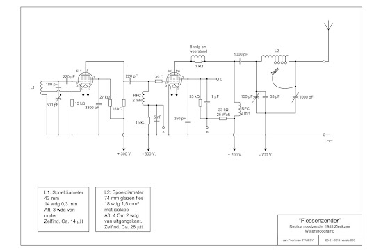
Interesting story for radio amateurs: About 20 km from where
I live, in Zierikzee (capital city of Schouwen Duiveland), Peter Hossfelt jr. –working
in a radio store/shop - managed to make a 80 mtr band transmitter to inform the rest
of Holland about the disaster that had taken place. A replica of this
transmitter can nowadays be found in the ‘ Watersnoodmuseum’ in Ouwerkerk.
More: https://www.pa3esy.nl/zelfbouw/Watersnoodzender-1953/html/Watersnoodzender_set.html


Hallo Ron, we hoeven ons nog niet heel erg zorgen te maken zo te zien. 10m zeespiegel stijging zou wel heel erg veel zijn. Hoe hoog moeten de dijken in dat geval wel worden? Ik woon dan zelf aan de waddenzee....maar als ik het (hoog) water vergelijk met zeg maar 30 jaar geleden zie ik zo geen verschil. 73, Bas
ReplyDeleteNee, zal zo'n vaart niet lopen Bas. Gelukkig hebben we hier inmiddels wat Deltawerken :-). Kijk je uit op de waddenzee ?
DeleteBijna Ron, ik woon er zo een 3 km vandaan. Uiteraard zitten de zeedijk van zo een 15m hoog ervoor en nog een lagere slaperdijk. Dus ik voel me redelijk veilig :-). 73, Bas
DeleteOk mooi,kan me herinneren dat je iets schreef dat je een Duits waddeneiland kunt zien liggen (Borkum?). Ik woon hier 3 km van het Haringvliet en 7 km van het Volkerak. En iets verder de Noordzee. Omgeven door water.
ReplyDeleteIk zal je kleinkinderen dan toch maar adviseren richting het oosten te vertrekken met de tijd. Goeie grafieken! :) Intrigerende afbeelding in van Oude Tonge!
ReplyDeleteHaha Johnno. Zo'n vaart loopt 't niet hoor. 15 cm stijging in 100 jaar is te overzien.
DeleteDan toch geef ik de opmerking dat de Deltawerken niet alles is. Constant onderhoud en repareren aan de keringen is niet zaligmakend. Dit blijkt nu ook oa bij de Haringvliet en Oosterscheldekering.
ReplyDeleteGoede info Jaap. Je hebt me via fb geupdatet. Dank. 73
Delete